Trail Walking Les Adrets-de-l'Estérel - Les esterets du lac - Photo
 ETMU5496
ETMU5496

User

© OpenStreetMap contributors
Length
Length
15.5 km
Max alt
Max alt
346 m
Uphill gradient
Uphill gradient
472 m
Km-Effort
Km-Effort  
22 km
Min alt
Min alt
84 m
Downhill gradient
Downhill gradient
469 m
Boucle
Boucle
No
Creation date :
2019-03-27 08:04:16.0
Updated on :
2024-05-08 15:15:22.193

(0 Reviews)

Walking
Walking
5h53
Difficulty : Medium

Scan this QR Code to open this trail in the SityTrail application

FREE GPS app for hiking

Logo SityTrail SityTrail

IGN / Geographical institutes

Download SityTrail from the App Store Download SityTrail from Google Play

Logo SityTrail SityTrail World

The world is yours!

Download SityTrail from the App Store Download SityTrail from Google Play Download SityTrail on Huawei AppGallery

About

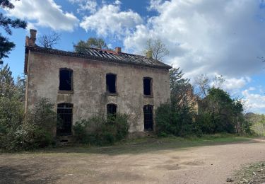
Trail Walking of 15.5 km to be discovered at Provence-Alpes-Côte d'Azur, Var, Les Adrets-de-l'Estérel. This trail is proposed by ETMU5496.

Description

balade de 16 km pour 472  et 469- aux alentours du lac de St Cassien.

Elevation profile

Positioning

Country:
France
Region :
Provence-Alpes-Côte d'Azur
Department/Province :
Var
Municipality :
Les Adrets-de-l'Estérel
Location:
Unknown
Start:(UTM)
320825 ; 4824237 (32T) N.

Trails nearby

Trail Walking Fréjus - Plan d'Esterel - mont Vinaigre - tour des Malavalettes - Photo
Walking
SabetMick

Walking

Medium
(1)
Fréjus, Provence-Alpes-Côte d'Azur, Var, France
15.4 km | 22 km-effort
5h 22min
Yes
Trail Walking Fréjus - barage du malpasser - Photo
Walking
pierro06

Walking

Very easy
(1)
Fréjus, Provence-Alpes-Côte d'Azur, Var, France
5.1 km | 7.6 km-effort
1h 55min
Yes
Trail Walking Fréjus - Plan d'Estérel - Mont Vinaigre - Photo
Walking
tracegps

Walking

Medium
(1)
Fréjus, Provence-Alpes-Côte d'Azur, Var, France
15.6 km | 22 km-effort
4h 0min
Yes
Trail Walking Montauroux - Frankrijk - Lac de St. Cassien - Provence - Photo
Walking
gpstracks

Walking

Very easy
(1)
Montauroux, Provence-Alpes-Côte d'Azur, Var, France
13.5 km | 18.7 km-effort
Unknown
No
Trail Mountain bike Tanneron - autour de tanneron - Photo
Mountain bike
papamorse

Mountain bike

Very difficult
(1)
Tanneron, Provence-Alpes-Côte d'Azur, Var, France
30 km | 41 km-effort
2h 50min
Yes
Trail Walking Fréjus - Lac de L’Avellan - Photo
Walking
Renefrt

Walking

Medium
Fréjus, Provence-Alpes-Côte d'Azur, Var, France
59 km | 99 km-effort
5h 43min
No
Trail Walking Montauroux - Le lac de Saint Cassien et la réserve biologique de Fondurane - Photo
Walking
boulinevelyne

Walking

Medium
Montauroux, Provence-Alpes-Côte d'Azur, Var, France
13.7 km | 18 km-effort
4h 51min
Yes
Trail Mountain bike Les Adrets-de-l'Estérel - Esterel 4 : Fait 06/04/23 TB des Adrets vers le pic de l'ours - Photo
Mountain bike
jl77130

Mountain bike

Medium
Les Adrets-de-l'Estérel, Provence-Alpes-Côte d'Azur, Var, France
47 km | 64 km-effort
5h 43min
Yes
Trail Mountain bike Les Adrets-de-l'Estérel - Esterel 6 : Fait 01/04/23 TB tour de l'Esterel par singles et DFCI - Photo
Mountain bike
jl77130

Mountain bike

Difficult
Les Adrets-de-l'Estérel, Provence-Alpes-Côte d'Azur, Var, France
52 km | 69 km-effort
6h 57min
Yes


Close
My subscriptions